Physical Science
Fall 2016
Course Description
Students will be introduced to natural disasters; the processes and energy sources that produce them, along with the spatial distribution and pattern of natural phenomena, while developing an understanding of the impact these phenomena have on human activity.
Students will be introduced to natural disasters; the processes and energy sources that produce them, along with the spatial distribution and pattern of natural phenomena, while developing an understanding of the impact these phenomena have on human activity.
- Determine what the roles are of natural disaster mitigation at a federal and local governmental level, community level, and individual.
- Analyze and understand natural processes that create disaster events such as: earthquakes, volcanoes, landslides, tsunamis, severe weather, disease, and climate change.
- Understand how natural hazards become disasters and ultimately catastrophes.
- Know how many natural processes are cylindrical meaning that they a frequency of recurrence which also influences their magnitude.
- Analyze the role humans play in creating natural disasters (i.e. population growth, poverty, environmental degradation, climate change, and politics).
- Understand the technology used to measure and analyze natural processes such as satellite imagery, aerial photography, Geographic Information Systems (GIS), Global Positioning Systems (GPS), and ground data.
Earthquakes and Volcanoes
Tracking Earthquakes
Magnitude: 6.1
Location: 30.502°N 142.080°E
Date/Time: 9/20/2016 4:21 PM UTC
Depth: 5.59 Miles
Convergent Oceanic to Oceanic - The Pacific plate is moving under the Philippine Plate.
Location: 30.502°N 142.080°E
Date/Time: 9/20/2016 4:21 PM UTC
Depth: 5.59 Miles
Convergent Oceanic to Oceanic - The Pacific plate is moving under the Philippine Plate.

|
Magnitude: 6.0
Location: 27.471°N 128.560°E
Date/Time: 9/26/2016 5:19 AM UTC
Depth: 25.01 Miles
Convergent Oceanic to Continental - The Philippine Plate moves beneath the Eurasian Plate.
Location: 27.471°N 128.560°E
Date/Time: 9/26/2016 5:19 AM UTC
Depth: 25.01 Miles
Convergent Oceanic to Continental - The Philippine Plate moves beneath the Eurasian Plate.

|
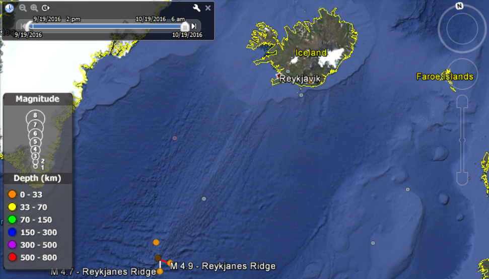
Magnitude: 5.9
Location: 57.206°N 33.326°W
Date/Time: 9/24/2016 4:26 AM UTC
Depth: 6.21 Miles
Divergent - The North American Plate is moving away from the Eurasian Plate
Location: 57.206°N 33.326°W
Date/Time: 9/24/2016 4:26 AM UTC
Depth: 6.21 Miles
Divergent - The North American Plate is moving away from the Eurasian Plate
|
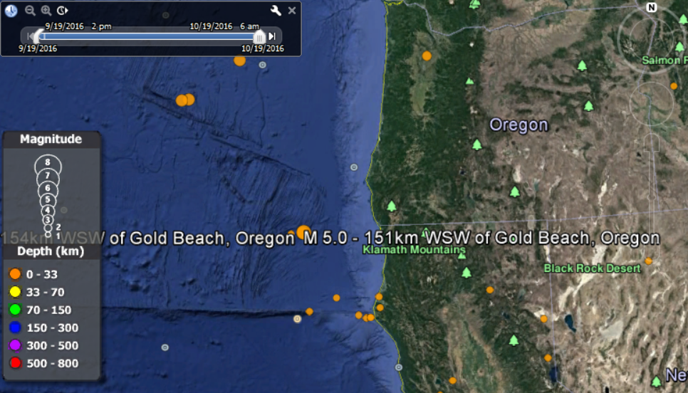
Magnitude: 5.0
Location: 41.867°N 126.111°W
Date/Time: 9/25/2016 5:01 AM UTC
Depth: 6.21 Miles
Transform - The North American Plate is moving beside the Pacific Plate
Location: 41.867°N 126.111°W
Date/Time: 9/25/2016 5:01 AM UTC
Depth: 6.21 Miles
Transform - The North American Plate is moving beside the Pacific Plate
|
Magnitude: 5.3
Location :36.386°N 27.585°E
Date/Time: 9/27/2016 8:57 PM UTC
Depth: 51.76 Miles
Convergent Continent to Continent - The African Plate meets the Eurasian Plate.
Location :36.386°N 27.585°E
Date/Time: 9/27/2016 8:57 PM UTC
Depth: 51.76 Miles
Convergent Continent to Continent - The African Plate meets the Eurasian Plate.

|
Identifying Volcanoes

Tungnafellsjökull Iceland Composite Continental to Continental |

Mauna Kea Shield Volcano Hawaii, USA Hot Spot |

Crater Lake Oregon, USA Caldera Ocean to Continental |

Bald Knoll Utah, USA Cinder Cone Hot Spot |
Should citizens become better at interpreting their world from an aerial viewpoint and what ethical and civil liberty issues might or should concern citizens about this technology?
I think that citizens need to become more skilled at being able to use aerial maps. Using Google Earth isn’t just a fun tool that allows people to travel anywhere in the world, it can also provide a realistic view of how our world is shaped. I thought it was interesting to see all of the sub-oceanic formations on the application. I think some of the ethical or civic issues surrounding aerial mapping are those involving privacy. People, especially in America, aren’t comfortable with the idea that a satellite or drone might be taking pictures of their property. Other things that might raise concern is how the technology will advance in the future. It may be possible to track the Earth in real time rather than piecing together millions of static images. This could lead to even greater fear of privacy invasion.
Reflect on how you thought about earthquakes in Utah before you started this assignment and how you think about it now that the course is over. Have any of your assumptions or understandings changed? Why?
I will admit that I wasn’t all that concerned with Earthquakes before taking this class. In multiple class discussions I spoke up about the fact that my job makes it impossible for me to even participate in any earthquake drills. Due to this, I felt, and still feel completely unprepared for an earthquake. I have gained a greater understanding of how and why Utah is at such a high risk of experiencing an earthquake. I’ve also learned exactly where the fault line runs along the Wasatch Front. I’ve always said that I don’t want to be anywhere near my workplace when the earthquake does hit, and the things I’ve learned in this class only reaffirmed that desire in me.
